The Plug Street Project - The Battle of Messines
Ypres
Messines
Ploegsteert Wood
Wytschaete
St Eloi
Warneton
River Douve
Messines Ridge
9th Aus
9th Aus
10th Aus
10th Aus
2nd NZ
2nd NZ
3rd NZ
3rd NZ
107th Bde
107th Bde
109th Bde
109th Bde
47th Bde
47th Bde
49th Bde
49th Bde
58th Bde
58th Bde
56th Bde
56th Bde
124th Bde
124th Bde
123rd Bde
123rd Bde
140th Bde
140th Bde
142nd Bde
142nd Bde
69th Bde
69th Bde
70th Bde
70th Bde
68th Bde
68th Bde
141st Bde
141st Bde
122nd Bde
122nd Bde
57th Bde
57th Bde
48th Bde
48th Bde
108th Bde
108th Bde
74th Bde
74th Bde
75th Bde
75th Bde
1st NZ
1st NZ
11th Aus
11th Aus
4th Bav
 4th Bav
40th Bav
 40th Bav
3rd Bav
 3rd Bav
2nd Div
2nd Div
35th Div
 35th Div
204th Div
 204th Div
Home
Archaeology
Site Index
Blog
No Man's Land: The International Group for Great War Archaeology
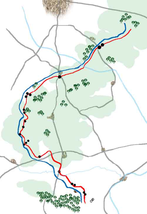
The Battle of Messines was fought over a 9 mile stretch of front line which had been almost static since 1914. The Germans having possession of most of the high ground, the Allies faced an uphill attack.

Select a unit from the map to discover more about the men involved.

Read about the planning and training for the battle, code named "Magnum Opus".


Website and ALL Material Copyright MMIX
- All Rights Reserved

The Plugstreet Archaeological Project

Website and Multimedia by Middleton House Productions